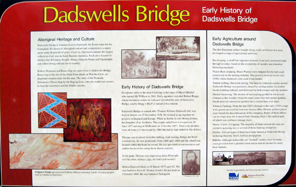
Dadswells Bridge, the small community on the Western Highway between Stawell and Horsham in Victoria, now has a series of signs to explain the locality's history and development.
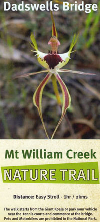
It also features a two-kilometre walking trail which exhibits many of the district's natural flora and fauna features.
These landmarks were developed co-operatively from the ideas of township volunteers assisted by kindred agencies such as Project Platypus and Landcare, Horsham Rural City Council and the Victorian Government's Parks Victoria agency and the Department of Sustainability and Environment.
Background
What is now an attractive roadside stop was known to the Jardwadjali Indigenous people ages ago; they ranged across this part of Victoria, close to the nearby Grampians mountain range.
The country was rich in plant and animal life while the nearby Grampians had spiritual significance for the people.
In the 1800s, the locality became known to early colonial settlers as Ledcourt Crossing (acknowledging nearby Ledcourt Station and the road crossing over Mt William Creek), then as Dadswells in the 1860s. It finally became Dadswells Bridge to mark the presence of Thomas William and Helena Dadswell - he is believed to have designed and helped construct the first bridge in the locality which enabled traffic to easily traverse Mt William Creek, and together Thomas and Helena operated Dadswells Hotel which became not just a hotel but which also housed the schoolhouse, post office and community centre.
The Dadswell family appears to have lived in the locality for about 20 years and during that time they were central to life in the area.
While the hotel had been an important staging post for travellers using horse-drawn coaches, the area suffered a reverse in fortunes in the late 1870s when the railway from Melbourne to Horsham was opened, but using a route which bypassed the area.
Since that time, the locality has relied heavily on the success of agricultural industry.
These days the community has a roadhouse, motel, caravan park, turkey farm, other agricultural pursuits and home-based enterprises. It is close to the northern end of the Grampians National Park and so attracts significant tourist traffic.
Modern times
In more recent times, the Dadswells Bridge community, under the leadership of the Progress Association, has made efforts to improve and upgrade township facilities.
These include the installations of a number of signs telling something of the district's history, and the adjacent walking trail which takes visitors through the Mt William Creek environs, grasslands, orchid and lily country, and stands of eucalypt trees. The trail area is also known for its platypus, small mammal and bird life.
A nature trail leaflet, describing features of the walk, has been produced for visitors.
- Information compiled January 2020 Return to Family Stories Index Page
|